Field Topography UTM 2.9.2
Paid Version
Publisher Description
Topographical surveying for definition of object position for UTM.
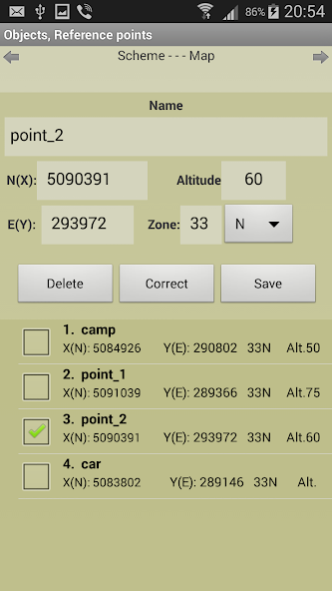
Calculations in full or brief coordinates.
Rectangular coordinates in meters. Altitude, range in meters.
All angles on scale 64-00 or 60-00 (settings option).
In DGP and IGP angles are available in degrees - minutes – seconds.
GPS location in rectangular coordinates.
Azimuth of the Sun, the Polaris in specified time.
Maintain a list of objects that may be used in which the tasks (250).
Read / write and append data from a file. The data file may edit/prepare a text editor, transfer methods available.
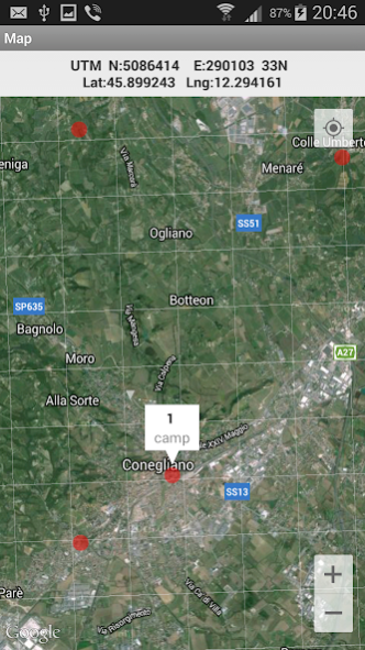
Google Maps, ArcGIS, MapBox, prepared ofline-atlases with markers points from the list (only with full coordinates).
Atlases in the format *.mbtiles can be created in SAS Planet, MobAC. Based on osmdroid.
Grid on the map.
When you touch the marker shows the number and name of the point.
When you touch the map shown rectangular coordinates of the location.
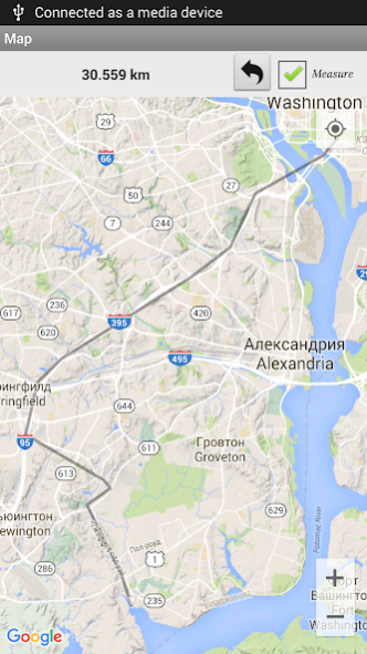
Measurement path length on the map.
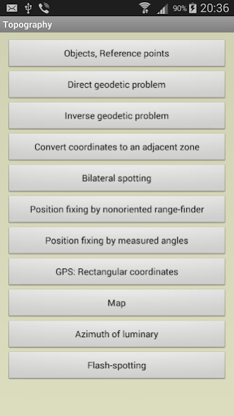
Tasks list:
Direct geodetic problem;
Inverse geodetic problem;
Convert coordinates to an adjacent zone;
Localizing with paired observation (readout from the base or directions);;
Binding undirected rangefinder (range up to 2 known points);
Binding by measured angles(between the left-middle and middle-right known points with anchor points);
Binding according to GPS (geodetic and rectangular);
Azimuth of luminary;
Localizing with a stopwatch (with the air temperature);
UTM-Grid on the map.
Settings:
- Maps: Google / ArcGIS / MapBox / prepared offline-atlases( *.mbtiles);
- The scale of thousandths (60-00/ 64-00)
- Color style
- Type of marker points on the map
- Grid on the map (no / 1km / 2 km )
- Save data to a file, read / write and append data from a file.
The program is distributed "as is". Its use - discretion and responsibility of the user.
About Field Topography UTM
Field Topography UTM is a paid app for Android published in the Geography list of apps, part of Education.
The company that develops Field Topography UTM is NordSoft. The latest version released by its developer is 2.9.2.
To install Field Topography UTM on your Android device, just click the green Continue To App button above to start the installation process. The app is listed on our website since 2022-02-20 and was downloaded 22 times. We have already checked if the download link is safe, however for your own protection we recommend that you scan the downloaded app with your antivirus. Your antivirus may detect the Field Topography UTM as malware as malware if the download link to nordsoft.topoUTM is broken.
How to install Field Topography UTM on your Android device:
- Click on the Continue To App button on our website. This will redirect you to Google Play.
- Once the Field Topography UTM is shown in the Google Play listing of your Android device, you can start its download and installation. Tap on the Install button located below the search bar and to the right of the app icon.
- A pop-up window with the permissions required by Field Topography UTM will be shown. Click on Accept to continue the process.
- Field Topography UTM will be downloaded onto your device, displaying a progress. Once the download completes, the installation will start and you'll get a notification after the installation is finished.
